|
St Thomas USVI
More Caribbean Islands Travel Guide - Hotels - Rental Cars and
Resort vacations
Find a premier Hotel & Resort at
Hilton Hotels.
or book Sheraton Hotels and Resorts
|
|
|
|
|
|
|
|
|
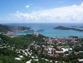
Saint Thomas, United States Virgin Islands
Saint Thomas is an island in the Caribbean Sea
and a constituent of the United States Virgin
Islands (USVI). Located on the island is the
territorial capital and port of Charlotte
Amalie.
Pre-Colonial History
The island was originally settled around 1500 BC
by the Ciboney people. They were later replaced
by the Arawaks and then the Caribs. Christopher
Columbus sighted the island in 1493 on his
second voyage to the "New World". The Caribs
seem not to have survived the first decades of
contact with Europeans, either due to disease or
deportation and extermination. Pirates likely
made use of the island as an occasional base in
the next 150 years.
[Danish Colonial Period
Map of U.S. Virgin IslandsThe Danish established
a presence on Saint Thomas as early as 1666, and
by 1672 had established control over the entire
island through the Danish West India and Guinea
Company. The land was divided into plantations
and sugar cane production became the primary
economic activity. As a result, Saint Thomas and
neighboring islands of Saint John and Saint
Croix became highly dependent on slave labor. In
1685 the Brandenburg American Company took
control of the slave trade on Saint Thomas, and
for some time the largest slave auctions in the
world were held there. Saint Thomas boasted a
fine natural harbor, known as "Taphus" for the
drinking establishments located nearby. In 1691
the primary settlement there was renamed
Charlotte Amalie in honor of the wife of
Denmark's King Christian V. It was later
declared a free port by King Frederick V.
While the sugar trade had brought prosperity to
the island's free citizens, by the early 19th
century Saint Thomas was in decline. The
continued export of sugar was threatened by
hurricanes, drought, and American competition.
In 1848, slavery was abolished and the resulting
rise in labour costs further weakened the
position of Saint Thomas' sugar producers. Given
its harbors and fortifications, Saint Thomas
still retained a strategic importance, and thus
in the 1860s the United States government
considered buying the island and its neighbors
from Denmark for $7.5 million, but failed to
find domestic legislative support for the bid.
"Beautiful Harbor of St. Thomas, West
Indies", stereoptical view, c. 1900
American Acquisition
In 1917 St. Thomas was purchased (along with
Saint John and Saint Croix) by the United States
for $25 million, as part of a defensive strategy
to maintain control over the Caribbean and the
Panama Canal during the First World War. U.S.
citizenship was granted to the residents in
1927. The U.S. Department of the Interior took
over administrative duties in 1931. American
forces were based on the island during the
Second World War. In 1954, passage of the U.S.
Virgin Islands Organic Act officially granted
territorial status to the three islands, and
allowed for the formation of a local senate with
politics dominated by the American Republican
and Democratic parties. Full home rule was
achieved in 1970.
The post-war era also saw the rise of tourism on
the island. With relatively cheap air travel and
the American embargo on Cuba, the numbers of
visitors greatly increased. Despite natural
disasters such as Hurricane Hugo (1989) and
Hurricanes Luis and Marilyn (1995), the island's
infrastructure continues to improve as the flow
of visitors continues.
|
|
|
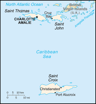
The United States Virgin Islands are a
group of islands in the Caribbean that is a
dependency of the United States. These islands
are geographically part of the Virgin Islands.
The U.S. Virgin Islands are made up of the four
main islands of St. Thomas, St. John, St. Croix
and Water Island and many smaller islands. They
are the only U.S. territory where traffic drives
on the left.
In Denmark, they are also referred to as The
Former Danish West Indian Islands
History
The Virgin Islands were originally settled by
the Ciboney, Carib, and Arawaks. The islands
were named by Christopher Columbus on his second
voyage in 1493 for Saint Ursula and her virgin
followers. Over the next three hundred years,
the islands were held by many European powers,
including Spain, England, Netherlands, France,
the Knights of Malta, and Denmark.
The Danish West India Company settled on Saint
Thomas in 1672, on Saint John in 1694, and
purchased Saint Croix from the French in 1733.
The islands became royal Danish colonies in
1754, their name in Danish translating as
Jomfruøerne. Sugarcane, produced by slave labor,
drove the islands' economy during the 18th and
early 19th centuries, until the abolition of
slavery by Governor Peter von Scholten on July
3, 1848.
During the submarine warfare phases of the First
World War, the USA, fearing that the islands
might be seized by Germany as a submarine base,
approached Denmark to sell the islands to the
USA. On January 17, 1917, the United States
bought the Danish West Indies for $25 million
and took possession of the islands on March 31.
The Danish Crown may have felt pressure to
accept the sale, thinking that the USA would
seize the islands, if Denmark was invaded by
Germany. U.S. citizenship was later granted to
the inhabitants of the islands in 1927.
Geography
Main article: Geography of the U.S. Virgin
Islands
The U.S. Virgin Islands are located in the
Caribbean Sea and the Atlantic Ocean, about 50
miles east of Puerto Rico. The territory
consists of four main islands: Saint Thomas,
Saint John, Saint Croix, and Water Island, as
well as several dozen smaller islands. The
combined land area of the islands is roughly
twice the size of Washington, D.C..
The U.S. Virgin Islands are known for their
white sand beaches, including Magens Bay and
Trunk Bay, and strategic harbors, including
Charlotte Amalie and Christiansted. Most of the
islands, including Saint Thomas, are volcanic in
origin and hilly. The highest point is Crown
Mountain, Saint Thomas (474m). Saint Croix, the
largest of the U.S. Virgin Islands, lies to the
south and has a flatter terrain. The National
Park Service owns more than half of Saint John,
nearly all of Hassel Island, and many acres of
coral reef. (See also Virgin Islands National
Park, Virgin Islands Coral Reef National
Monument, Buck Island Reef National Monument,
Christiansted National Historic Site, and Salt
River Bay National Historic Park and Ecological
Preserve.)
The Virgin Islands lie on the boundary of the
North American plate and the Caribbean Plate.
Natural hazards include earthquakes, tropical
cyclones and tsunamis.
|
|
|
Background:
|
During the 17th century, the archipelago was divided
into two territorial units, one English and the
other Danish. Sugarcane, produced by slave labor,
drove the islands' economy during the 18th and early
19th centuries. In 1917, the US purchased the Danish
portion, which had been in economic decline since
the abolition of slavery in 1848. |
|
Location:
|
Caribbean, islands between the Caribbean Sea and the
North Atlantic Ocean, east of Puerto Rico
|
|
Geographic coordinates:
|
18 20 N, 64 50 W
|
|
Map references:
|
Central America and the Caribbean |
|
Area:
|
total: 352 sq km
water: 3 sq km
land: 349 sq km |
|
Area - comparative:
|
twice the size of Washington, DC |
|
Climate:
|
subtropical, tempered by easterly trade winds,
relatively low humidity, little seasonal temperature
variation; rainy season May to November |
|
Terrain:
|
mostly hilly to rugged and mountainous with little
level land |
|
Nationality:
|
noun: Virgin Islander(s)
adjective: Virgin Islander |
|
Ethnic groups:
|
black 80%, white 15%, other 5%
note: West Indian (45% born in the Virgin
Islands and 29% born elsewhere in the West Indies)
74%, US mainland 13%, Puerto Rican 5%, other 8%
|
|
Religions:
|
Baptist 42%, Roman Catholic 34%, Episcopalian 17%,
other 7% |
|
Languages:
|
English (official), Spanish, Creole |
|
Currency:
|
US dollar (USD)
|
|
Currency code:
|
USD |
|
Exchange rates:
|
the US dollar is used
|
|
|
|
|
|